


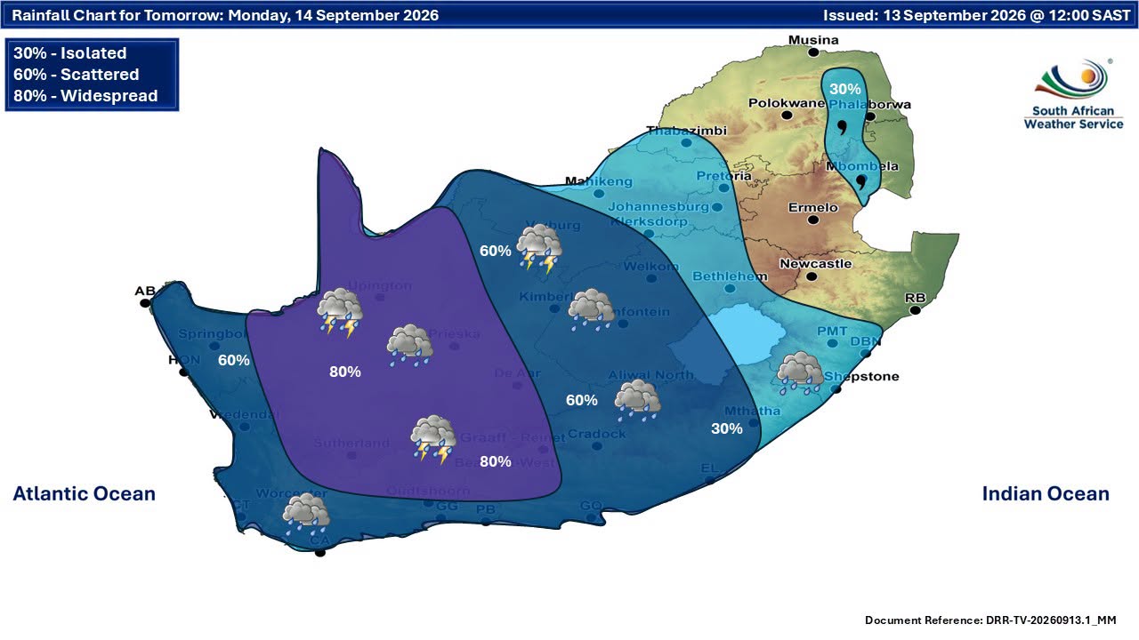
The South African Weather Service has issued multiple severe weather warnings for 14 September 2026, with disruptive rain, severe thunderstorms and damaging winds expected across several provinces.
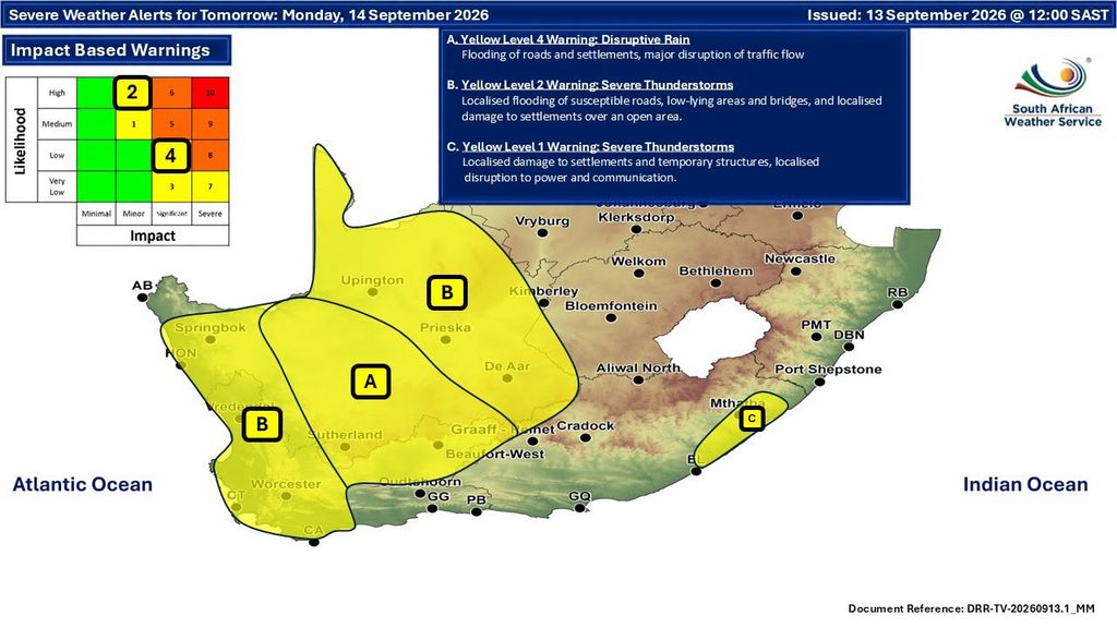
A Yellow Level 4 warning for disruptive rain is in place for eastern Namakwa in the Northern Cape and the Central Karoo District of the Western Cape, where flooding of roads and settlements and major traffic disruption are expected.
Cape Town, the West Coast, Cape Winelands and Overberg are also under a Yellow Level 2 severe thunderstorm warning, while damaging wind warnings extend across several other parts of South Africa.
A cut-off low pressure system developing west of the country is expected to affect the Western and Northern Cape, bringing intermittent showers and thundershowers, heavy downpours at times, possible small hail, lightning and a significant drop in temperatures over high-lying areas.
Level 4 disruptive rain warning for Northern and Western Cape
The highest impact-based warning in the forecast is a Yellow Level 4 warning for disruptive rain.
It applies to eastern Namakwa in the Northern Cape and the Central Karoo District of the Western Cape.
The rain is expected to result in flooding of roads and settlements as well as major disruption to traffic flow.
The broader Northern Cape forecast is cloudy, windy and cool to cold, with scattered showers and thundershowers becoming widespread in the east and central parts.
The Western Cape will be cloudy and cool to cold, with scattered showers and thundershowers becoming widespread over the north-eastern parts.
Severe thunderstorms forecast for Cape Town
A Yellow Level 2 warning for severe thunderstorms covers the Nama Khoi and Kamiesberg municipalities in the Northern Cape.
In the Western Cape, the warning includes the West Coast, Cape Winelands, Overberg District and the City of Cape Town.
Excessive lightning could result in localised injuries to people and livestock, while power disruptions could affect services.
The Western Cape coast will experience moderate to fresh westerly to north-westerly winds.
Cut-off low brings heavy downpours, hail and rough seas
The South African Weather Service has also issued an advisory linked to a cut-off low pressure system developing west of the country.
The system is expected to affect the Western and Northern Cape provinces from Sunday into Monday, 14 September 2026.
The public and small-stock farmers are advised of intermittent showers and thundershowers accompanied by heavy downpours at times.
Possible large amounts of small hail and lightning are also expected, together with a significant drop in temperatures over high-lying areas.
Windy conditions are forecast along the coast and in the interior, while very rough seas reaching between 4.0 and 4.5 metres are expected south of Table Bay.
Damaging wind warnings across several provinces
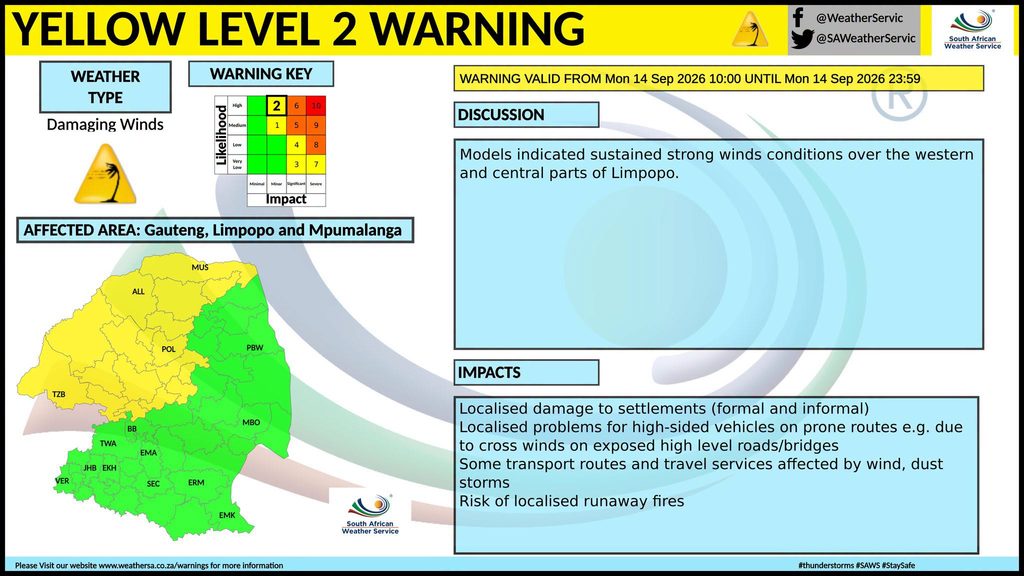
A Yellow Level 2 warning for damaging winds covers the North West, eastern parts of the Northern Cape, central and western parts of the Free State and central and western parts of Limpopo.
The warning also extends to places over the northern parts of the Eastern Cape.
Possible impacts include damage to informal settlements and disruptions to power and communications.
A separate Yellow Level 1 damaging wind warning is in place for parts of the extreme north-eastern Eastern Cape coast and adjacent interior.
The north-eastern coast and adjacent interior of the Eastern Cape are also under a Yellow Level 1 severe thunderstorm warning.
Localised damage to settlements and temporary structures as well as disruption to power and communications are expected in places.
Damaging winds and waves warning
A Yellow Level 2 warning for damaging winds and waves is in place between Port Edward and Richards Bay and the adjacent interior.
The conditions could result in localised disruption to small harbours or ports for a short period, difficulty in navigation and localised damage to infrastructure and settlements.
Along the Wild Coast, winds are forecast to become fresh to strong north-easterly, reaching gale force from the afternoon.
Extremely high fire danger in Limpopo
Despite the widespread rain and thunderstorm forecasts elsewhere, extremely high fire danger conditions are expected over the western parts of the Waterberg District and the Blouberg municipality in Limpopo.
Weather forecast across South Africa
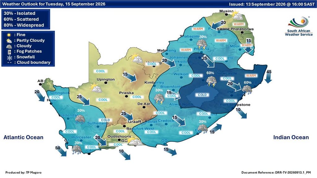
Gauteng will be partly cloudy and cool to warm, with isolated showers and thundershowers. The expected UVB sunburn index is high.
Mpumalanga will be cloudy in the east, with morning drizzle and fog patches in places over the eastern Highveld and escarpment. Elsewhere it will be partly cloudy and cool to warm, with isolated showers and thundershowers in the extreme south-west.
Limpopo will experience morning drizzle along the escarpment, with partly cloudy and cool to warm conditions elsewhere. Isolated showers and thundershowers are forecast in the south-western Bushveld, while it will be fine in places over the north-west.
The North West will be partly cloudy, windy and cool to warm, with scattered showers and thundershowers becoming isolated in the east.
The Free State will be partly cloudy, windy and cool to warm, with scattered showers and thundershowers becoming isolated in the north-east.
The Northern Cape will be cloudy, windy and cool to cold, with scattered showers and thundershowers and widespread activity in the east and central areas.
The Western Cape will be cloudy and cool to cold, with scattered showers and thundershowers becoming widespread over the north-east. The expected UVB sunburn index is moderate.
The western half of the Eastern Cape will be windy in the north and otherwise cloudy and cool to warm. Scattered showers and thundershowers are forecast, becoming widespread in the north-west.
The eastern half of the Eastern Cape will be warm to hot with morning fog in places south of the escarpment, otherwise becoming cloudy, windy and cool with scattered showers and thundershowers.
KwaZulu-Natal will have morning fog patches over the interior, followed by partly cloudy and cool to warm conditions with isolated showers in the south. The expected UVB sunburn index is high.





Related Articles

UFC 331: What time Van vs Pantoja 2 starts in South Africa and full fight card
Joshua Van and Alexandre Pantoja will meet again with the UFC flyweight...

The symptoms we learn to live with could be worth talking about
Pain, fatigue or simply not feeling like yourself can become something you...

Think you can afford that car? The monthly instalment doesn’t tell the full story
A car might fit comfortably into your finance application, but the monthly...



Petrolhead to EV convert: How electric cars are changing driving pleasure
For decades, the roar of an engine was part of the thrill...
