


The South African Weather Service (SAWS) has upgraded its severe weather alerts ahead of a powerful cut-off low-pressure system expected to hit parts of the country from Wednesday, 3 June 2026.
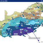
The latest forecast warns of life-threatening flooding, mudslides, disruptive snowfall and dangerous sea conditions across sections of the Western Cape and Eastern Cape, with some areas now placed under an Orange Level 8 warning.
Orange Level 8 warning issued for Garden Route
The highest warning level currently in place affects coastal and adjacent inland areas between Mossel Bay and Plettenberg Bay.
SAWS warns the region faces:
- Widespread flooding
- Mudslides
- Settlement displacement
- Dangerous travel conditions
- Threats to life
The warning remains in effect for Wednesday and Thursday.

Orange Level 5 warning expands into Eastern Cape
An additional Orange Level 5 warning has been issued for areas stretching from Plettenberg Bay to East London.
Authorities warn of:
- Flooding
- Mudslides
- Dangerous river conditions
- Disruption to roads and infrastructure
- Possible settlement evacuations
More rain warnings issued
Yellow Level 4 warning
Heavy rain is expected across:
- Eastern Central Karoo
- Western Garden Route District
- Swellendam Municipality
Yellow Level 2 warning
Localised flooding risks remain in southern parts of the Eastern Cape.
Affected areas may experience:
- Flooded roads
- Overflowing rivers
- Waterlogged low-lying areas
- Dangerous bridge crossings
Rough seas and damaging coastal conditions expected
SAWS also issued a Yellow Level 2 warning for damaging winds and waves between Cape Point and Plettenberg Bay.
Small vessels and coastal navigation may become dangerous as rough sea conditions intensify.
Snow and bitter cold forecast
An advisory remains in place for the Eastern Cape between Wednesday and Friday.
The weather service warns the combination of:
- Snowfall
- Heavy rain
- Flooding
- Freezing temperatures
- Rough seas
could create extremely dangerous conditions, particularly for rural communities and livestock farmers.
Cape Town forecast
Cape Town is expected to turn cloudy with isolated rain developing from mid-morning.
Forecast:
- Minimum: 13°C
- Maximum: 20°C
- UVB Index: Very High
Winds will shift from north-westerly to south-easterly during the afternoon.
George forecast
George is forecast to experience cloudy conditions with scattered rain developing later in the day.
Forecast:
- Minimum: 14°C
- Maximum: 19°C
Gqeberha and East London forecast
Gqeberha
- Partly cloudy
- Isolated showers expected at night
- Temperatures: 17°C to 20°C
East London
- Partly cloudy becoming cloudy
- Isolated showers expected during the evening
- Temperatures: 19°C to 23°C
Gauteng to stay cool and partly cloudy
Johannesburg and Pretoria are expected to remain partly cloudy with cool daytime temperatures.
Johannesburg
- Minimum: 7°C
- Maximum: 19°C
Pretoria
- Minimum: 6°C
- Maximum: 20°C
- UVB Index: High
KwaZulu-Natal remains warm for now
Durban and Richards Bay are forecast to remain fine and relatively warm ahead of the approaching cold shift later this week.
Durban
- Fine conditions
- Temperatures: 17°C to 24°C
- Moderate north-easterly winds
Richards Bay
- Fine and warm
- Temperatures: 14°C to 27°C
Motorists and residents urged to stay alert
SAWS has advised residents and travellers in affected regions to:
- Avoid flooded roads and bridges
- Delay unnecessary travel
- Monitor official weather updates
- Prepare for possible road closures
- Take precautions for livestock and pets
The weather service says conditions may still intensify as the cut-off low develops further over the southern parts of the country.




Related Articles

Shoprite tests FillRite refills that let shoppers buy essentials from R5
What if you only have R5 for cooking oil, sugar or another...

Brad Binder joins BMW for new WorldSBK chapter in 2027
South African MotoGP star Brad Binder is heading to WorldSBK after signing...

Caravan chocolate is back in South Africa, but only for a limited time
Remember Caravan? The chocolate bar that disappeared from South African shelves is...



New DStv packages and prices: What changes from 17 September
DStv is introducing a new package structure in South Africa from 17...
